Rains
Topics available on this page:
- Rain
- Effects for aviation
- Runway contaminated with water blade
- Classification of aquaplaning or hydroplaning types
- Mirroring
- Accidents and incidents
Heavy rains are formed by drops of water with a diameter of more than 0.5 mm that are noticeably separated from the clouds.
As the water droplets that make up the clouds grow and reach enough weight to overcome the ascending forces, they begin to fall and eventually reach the ground.
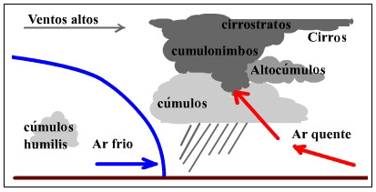
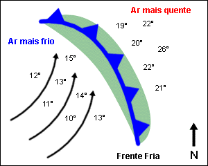
The rains are usually caused by the encounter between two air masses (one cold and one hot), due to a front or an elevation of a cloud by ascending currents .

Note 8-1
The presence of a cold front is a good indication of the possibility of moderate and strong rains occurring at the route logo or at the destination aerodrome.
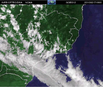
During the flight planning phase, consultation and interpretation of satellite images may provide elements for identifying the location and area of coverage of the cold front and the respective points of formation where there is a possibility of rain showers.
The figure below is an example of a satellite image that indicates the entrance of a cold front responsible for heavy rain in the southeastern region of Brazil (photo of the Satellite GOES, from 18h UTC on 02/17/2010).

Note 8-2
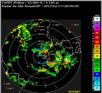
The combination of the satellite images and the sequential radar images of the meteorological formation enables the direction of the cold front formations to be detected.
Image of the weather radar of São Roque - SP
Due to the differences in intensity of the various types of precipitation, the terms "light", "moderate" and "strong" were adopted for aeronautical purposes, taking into account that the visibility of the air decreases with increasing intensity.
This precipitation intensity can be measured by sensors that record the accumulation of water for a unit of time.
For aeronautical purposes, visibility is defined as the greatest distance at which an object of appropriate size can be seen and identified, when observed against a bright background.
According to the intensity, the rains can cause reduced visibility to values below 5,000m.
Such a reduction in visibility can be potentially dangerous for aircraft not approved to operate under instrument flight conditions (IMC). In this situation, the pilot may be induced to make the decision to fly at low altitude in an attempt to maintain visual contact with the terrain.

Note 8-3
Decreasing vertical separation with the ground, reduces safety margins to safely conduct safe flight as it increases the risk of collision with terrain elevations and obstacles in the ground.
In landing operations, the reduction of visibility caused by heavy rains, if associated with the condition of ceiling below the minimums, can hamper the visualization of the bedside by the crew.
Such visualization may occur at the time the aircraft is below the MIM ( Minimun Descend Altitude ) established by the instrument approach chart for said headland.
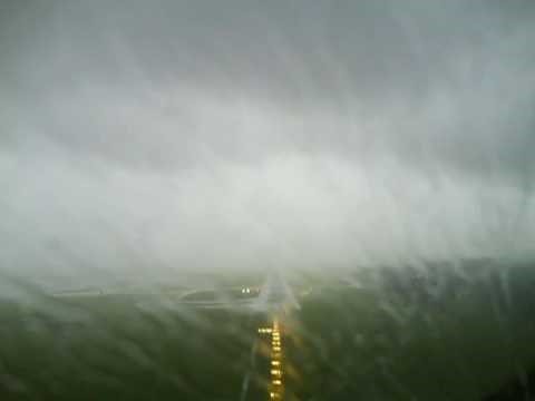
Source: https://www.youtube.com/watch?v=P3GRpWSRc5c

Note 8-4
In this situation, when visual contact with the lane is not reached, it is recommended to perform the procedure of a rush on the MDA (Minimun Descend Altitude ).
See the comparative conditions of visibility at the location of the fall of an aircraft that suffered spatial disorientation under conditions of horizontal visibility restricted to 1,500m due to rainfall.
Click on the image to enlarge 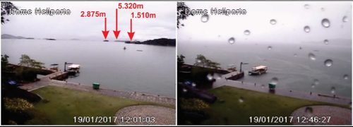
Source: Final accident report A-013 / CENIPA / 2017
Runway contaminated with water
Another danger caused by heavy rains, especially in the summer periods in Brazil, is the increase in the likelihood of accumulation of water depth in the runway after take-off.
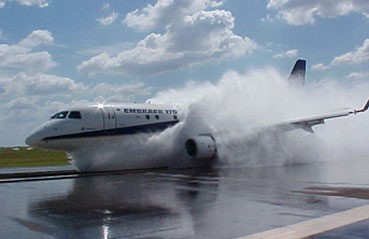
Source: Mundo Aero
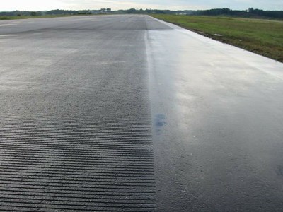
Source: https://maisprojeto.wordpress.com/category/pista-e-asfalto/
In a runway contaminated by accumulation of water depth, the excess speed used in the landing of the aircraft may compromise the adhesion of the tires to the ground, which may cause the loss of directional control of the aircraft.
Aquaplaning or hydroplaning is a phenomenon that occurs when a fluid (usually water) interposes between the tire of the aircraft and the pavement. This fact leads to the loss of tire contact with the runway surface, since the friction is affected by the viscosity and mass of the fluid. In these cases, in general, there is inadequate fluid drainage through the grooves of the tire.
In such circumstances, the friction force becomes almost nil and insufficient to keep the wheel spinning.

Note 8-5
Once the hydroplaning has commenced, the speed of the aircraft must be reduced immediately to allow the wheel to rotate again.
Classification of aquaplaning or hydroplaning types
Hydroplaning (or aquaplaning) can be of three types: dynamic hydroplaning, viscous hydroplaning and hydroplaning with destruction of tire rubber.
- Dynamic - results from the layer of water on the track that lifts the tire leading to loss of contact with the surface, making it slide without turning. In this situation, both manual and automatic brakes, with or without anti- skid ( anti- skid ), become inefficient in braking the aircraft.
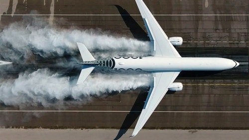
Source: Airbus

Note 8-6
In such a situation, the pilot must decelerate the aircraft by means of the reverse power of the engines, requiring its use immediately upon landing, at which point its efficiency is at its maximum.
Total dynamic hydroplaning requires a considerable amount of water, as occurs with automobile tires, when they pass over a pool of water, for example. The occurrence of partial dynamic hydroplaning is more usual, in that the complete separation between the tire and the track does not occur all the time, although this reduction of grip allows the tire to slip. In this case, successive hydroplaning can be experienced interspersed with brief stretches of reduced adhesion.
- Viscose - occurs when there is presence of water, dust, traces of rubber or oil, increasing the viscosity of the track and making it difficult to contact the wheels with the surface. It is very common in situations of recent rainfall. Its characteristic is that it can occur at much lower speeds than in dynamic aquaplaning. It is also associated with smooth surfaces, with possibility of occurrence in the touch zone of the lane, due to the presence of rubber deposits that naturally accumulate in that area. Viscous hydroplaning can be checked, even if there are no sheets or puddles of water in the landing and takeoff runway.
- Rubber Reversal - Hydroplaning with tire rubber destruction. It is also known as vulcanization hydroplaning and occurs when the brakes are caught on a wet or wet track. The friction between a slipped (blocked) tire and the runway surface generates enough heat to turn the moisture into water vapor. The steam causes the rubber to melt, producing pressure under the tire and partially separating it from the runway surface. The seal formed on the tire ends up delaying the water dispersion and the generated steam contributes to the aquaplaning as it hinders the friction between the tire and the track.

Note 8-7
The adhesion requirements for landing and take-off runways in Brazil are set out in ANAC Resolution 236 of 05/06/2012 .
In order to guide the aerodrome operator to monitor the water slide in the landing and takeoff runway, in case of moderate or strong rain that could cause contamination of the runway, ANAC published on the aerodrome page an alert to operators of aerodromes.
One of the objectives of the alert is to encourage the dissemination of more accurate information to the Air Traffic Service (ATS) regarding the existence of water depths on the surface of runways.
Read the alert on the Runway contaminated with water page: http://www.anac.gov.br/assuntos/setor-regulado/aerodromos/certificacao/runway-safety/lamina-dagua
Source: justplanes.com
There are now some types of sensors that can measure the height of the water slide on the runway.
After rainfall, the accumulation of water on the surfaces of the landing strip (green areas and taxiways ) can cause a "mirroring" phenomenon, impairing the identification of visual aids by the pilot.
In an aeronautical incident occurred at Guarulhos International Airport, an aircraft landed on the parallel taxiway to the right of the 27R bed in use. The CENIPA report (I-011 / CENIPA / 2010) concluded that the intense luminosity caused by the frontal position of the sun and the wet surface in the vicinity of the runway caused a "mirroring" phenomenon and that this fact impaired the visualization of the runway and its aid by the crew.
The report states that the crew could not see the approach lights, runway lights, the PAPI (Precion Approach Indicator) or track markings, attributing these facts to the intense reflection of the sun's rays that caused a phenomenon of "mirroring", making it difficult to perceive these visual references.
The approach continued, with the crew assuming that the asphalted track which, although also wet and reflective of lesser intensity, was runway 27R, which in fact proved to be Taxiway B.
In the flight planning phase, the occurrence of heavy rains at the departure aerodrome, along the route or at the destination aerodrome can be identified by consulting the meteorological bulletins.
The rain was mentioned in the investigation reports of the following accidents / incidents:
- A-013 / CENIPA / 2017
- A-081 / CENIPA / 2015
- A-134 / CENIPA / 2014
- IG-009 / CENIPA / 2014
- IG-018 / CENIPA / 2012
- A-032 / CENIPA / 2012
- A-005 / CENIPA / 2008
CENIPA reports available at http: // prevencao # mce_temp_url # .potter.net.br / report / page / 1
- A320, Halifax NS Canada, 2015
- A333, Montréal QC Canada, 2014
- A332, Jakarta Indonesia, 2013
- B744 / MD90, Chitose Japan, 2008
- B732, vicinity Abuja Nigeria, 2006
- A343, Toronto Canada, 2005
- AS50, en-route, Hawaii USA, 2005
- B737, Chicago Midway USA, 2005
- B744, Bangkok Thailand, 1999
- B752, Girona Spain, 1999
- B743, vicinity Won Guam Airport, Guam, 1997
- B732, vicinity Washington National DC USA, 1982
*As notas que contém itens de regulamentos brasileiros não foram traduzidas para que a interpretação delas não seja diferente da interpretação pretendida.
**Notes containing items of Brazilian regulations have not been translated so that their interpretation is not different from the intended interpretation.
Did you find errors in this content ? Send email to meteorologia@anac.gov.br to report.
