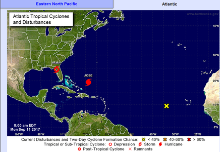
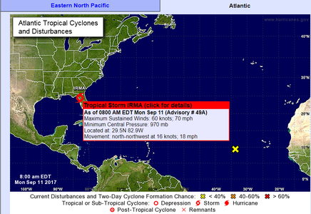
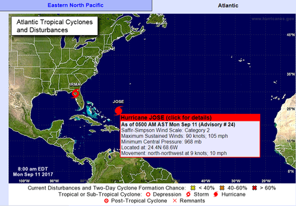
Hurricane
The hurricane is named for tropical cyclones with a continuous wind speed of 63 knots or more, occurring in the North Atlantic Ocean, Caribbean Sea, Gulf of Mexico, and the eastern Pacific Ocean. This same tropical cyclone is known as a typhoon in the western Pacific and as a cyclone in the Indian Ocean.
Topics available on this page:
- Tropical cyclones
- Alerts and warnings
- Hurricane Preparedness Guide
- Hurricane Warning
- Hurricane Alert
Also called typhoons or hurricanes, tropical cyclones are deep cyclonic vortices that develop between latitudes from 10º to 20º latitude, with a diameter of about 1,000 km and a very low pressure core - about 50 to 100 HP less than observed in the surrounding area.
They appear on the tropical ocean, where the water temperature is high (about 27º) and the water vapor abundant, from a low pressure center.
Not all cyclonic vortices evolve into a hurricane. Some are simple migratory low pressure centers, termed tropical storms and soon disappear. Others, however, intensify and can turn into hurricanes, moving quickly or slowly or still parking for many hours, causing destruction wherever they go.
There are two basic types of tropical cyclones: those whose maximum intensity is close to the earth's surface and decreases with altitude (hot core) and others whose maximum intensity occurs in the upper troposphere, decreasing towards the surface (cold core).
Tropical cyclones are easily identified in meteorological satellite images due to the typical spiraling cloud system. At the center of the system there is a circular area 25 to 65 kilometers in diameter, known as the "eye", where the atmospheric conditions are calm and cloudless. The absence of clouds in the center occurs due to the intense movement of the air that contributes to the reduction of the atmospheric pressure to the surface. In general, there is a reduction in the size of the eye when the storm becomes more intense.
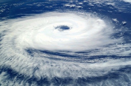
Tropical Cyclone - Catarina Hurricane - BRAZIL. Photo: Freepik
The wind speed associated with the phenomenon easily surpasses 100 km / h in the area near the eye, in some cases reaching 200 km / h, decreasing towards the periphery of the cyclone.
Around the eye, convective cloud walls are formed that reach the threshold of the tropopause, produced by intense convective activity and causing intense downpours (with great release of latent heat, supplying the energy system), accompanied by lightning and thunderstorms, precipitation, especially in the area near the center of the cyclone.
Tropical cyclones last about a week. They usually appear in late summer and early fall on the tropical strip of the Pacific, North Atlantic and Indian Oceans.
In terms of wind speed, tropical cyclones are classified as follows:
- Tropical depression: when the tropical cyclone presents wind with velocity less than 34 KT;
- Tropical storm: when the tropical cyclone presents winds with a speed of 34 to 63 KT;
- Typhoon, hurricane, cyclone: when the tropical cyclone presents wind with a speed greater than 63 KT.
Images of wind speed during the passage of a hurricane: http://www.mahobeachcam.com/
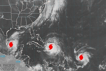
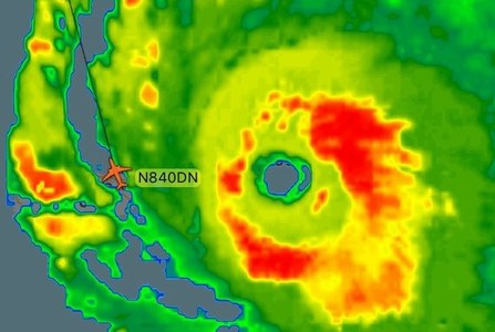
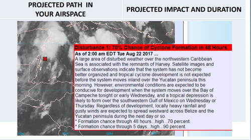
The civil aviation authorities of countries that are usually affected by this phenomenon seek to closely monitor the forecasted hurricanes by issuing warnings and warnings about the storms.
Hurricane Alert Service Page: http://www.nws.noaa.gov/om/hurricane/index.shtml
Eventually, at some aerodromes it is necessary to protect air traffic control facilities along the storm path and be able to quickly resume operations after the hurricane has passed. Resuming the operation of flights in a timely manner is essential to support the areas affected by the destruction.
Aerodrome control towers located in hurricane-prone areas are designed and built to sustain the force of a hurricane's winds. Each control tower has maximum wind sustainability. When the winds approach this level, the controllers evacuate the control towers. They can remain in the service building on a lower level safe and are ready to return to work as soon as the storm passes. In many cases, it is also necessary to protect communications equipment and air navigation aids.

In some cases, as the hurricane storm approaches, aerodrome surveillance radar antennas may be deactivated to minimize possible wind damage and allow radar coverage to resume rapidly after the storm has passed .
Severe weather conditions associated with the passage of a hurricane cause delays and cancellations of many flights that would pass through the storm's direct route or surrounding area. To ensure the safety of operations, local aviation authorities may also impose restrictions on local airspace or temporary flight restrictions.
https://www.faa.gov/air_traffic/flight_info/hurricane_season/

Site with information on the general aerodrome conditions of the USA: estimated time of delay in departures, taxi and arrivals and waiting time in the air. http://www.fly.faa.gov/flyfaa/usmap.jsp
Some aerodromes located in the disaster area caused by the hurricane can be closed for several days. On some occasions, they remain closed so that they can support the response and the recovery effort or because the roads that give access to the airport are inaccessible.
- http://agenciabrasil.ebc.com.br/internacional/noticia/2017-09/aeropuerto-de-havana-reinicia-voos-apos-passagem-do-furacao-irma
- http://agenciabrasil.ebc.com.br/internacional/noticia/2017-09/a-imiami-carda-facility-at-which-disasters-arevalued

If you need to fly to a region that is close to being hit by a hurricane, it is important to consult, at the time of flight planning, in addition to NOTAM and other regular weather available, the warnings issued by the civil aviation authority of the affected country.
In addition, it is necessary to review the latest information on flight restrictions in areas affected by the hurricane.
Always be aware of weather conditions throughout your planned route.
In some cases, it is advisable to contact the destination aerodrome before taking off for the most up-to-date information on weather conditions at the aerodrome.
Below are examples of aviation-related weather reports that may contain information related to hurricane activity:
Meteorological information of the airport of the tropical island of Saint Martin that was divulged during the passage of Hurricane Irma:
TAF: TNCM 060012Z 0600/0624 04014KT P6SM VCSH SCT018 FM060300 01025G35KT P6SM -SHRA VCSH SCT015 BKN060 OVC080 FM060500 33055G75KT 6SM -SHRA SCT025 BKN050 FM060700 * * 300140G160KT 6SM -SHRA BKN015 OVC030 FM061100 26090G120KT 6SM -SHRA BKN015 OVC030 FM061700 20055G75KT 6SM -SHRA SCT025 BKN050
Formal note released by the National Hurricane Center (NHC). This communication, accompanied by recommendations, is released when analysis of atmospheric conditions indicates that coastal areas and / or group of islands will be potentially under hurricane threat within the next 24 hours. The Hurricane Warning is used to inform the general population as well as specific interests about the storm's location, intensity, and displacement.
Formal note released by the National Hurricane Center (NHC). This communication, accompanied by recommendations, is disclosed when the analysis of atmospheric conditions indicates that coastal areas and / or group of islands are potentially under threat of hurricane in the period between the next 24 and 36 hours. Hurricane Warning is used to inform the general population as well as specific interests about the storm's location, intensity, and displacement.

