Wind gusts
Topics available on this page:
Wind

Source: https://www.faa.gov/regulations_policies/handbooks_manuals/aviation/phak/media/14_phak_ch12.pdf
Wind is defined as moving air caused by a pressure difference between two regions, due to temperature variations.
Whenever there is a pressure difference between two points, the air will move from the point of greatest pressure to the point of least pressure in the horizontal direction. This phenomenon is called wind.
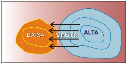
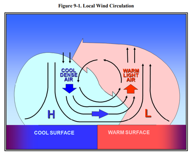
Source: https://www.faa.gov/documentLibrary/media/Advisory_Circular/AC_00-6B.pdf
At higher levels, wind moves from Ecuador towards the poles. At lower levels, the wind circulation may be clockwise or counterclockwise, depending on the forces of Coriolis and the latitude at which the mass of air is located.
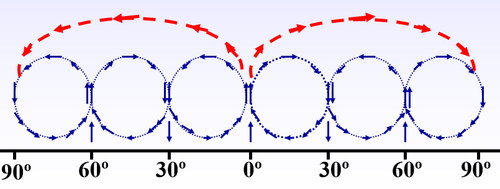
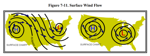
Source: https://www.faa.gov/documentLibrary/me # mce_temp_url # d # mce_temp_url # ia / Advisory_Circular / AC_00-6B.pdf
This circulation causes the formation of cold fronts and jet streams.
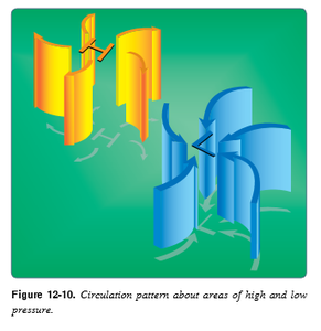
Source: https://www.faa.gov/regulations_policies/handbooks_manuals/aviation/phak/media/14_phak_ch12.pdf
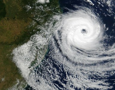
Satellite Image
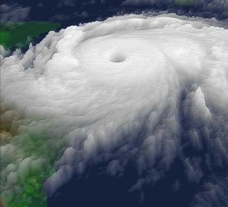
Satellite Image
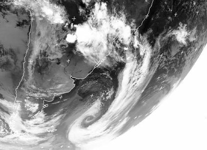
Satellite Image
Wind speed is the distance traveled in the unit of time; expressed in knots (KT), from 01 to 01 KT.
The ideal wind for landing and takeoff is always the opposite wind (bow wind). Never the tail wind.
In the example of this landing strip, considering that it is aligned with the rose of the winds, the ideal wind for operation would be a wind with the direction of 180 degrees and up to 10kt maximum.
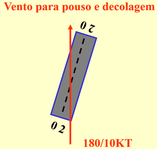
Bow Wind
The bow wind is best suited for landing and take-off operations, as it allows for an anticipated lift gain when compared to the tail wind.
Operation against the wind generates some of the required lift, resulting in a lower ground speed and less runway clearance. The headwind can also provide a higher climbing ratio.
Landing against the wind may also provide an operation where it is necessary to use less track distance and slower speed upon reaching the touch zone.
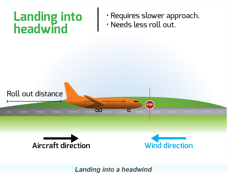

When the wind changes direction, air traffic control bodies often alter landing and takeoff operations using another headland. Up to 5kt, the wind would be considered harmless for landing and takeoff operations and does not require a headland change.
Tail wind
A takeoff with tailwind requires more runway and landing distance and higher speeds to generate sufficient lift for the flight. The climb rate can also be affected by the tailwind.
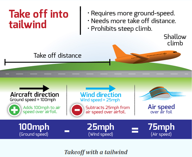

Landing with tailwind can cause the aircraft to touch the lane at a higher speed.

Note 3-1
Variable-direction wind and tail predominance, with an intensity of 10 knots or greater, may boost the excess speed during aircraft landing. In this situation, the crew must be prepared to properly assess available speed and lane length information for a safe landing.
Cross Wind
A potentially dangerous situation for landing and take-off operations is when the operation takes place under the effect of the so-called crosswind.
This phenomenon occurs when the wind is in the direction direction to the side of the aircraft.
The crosswind can change the expected course of the aircraft.
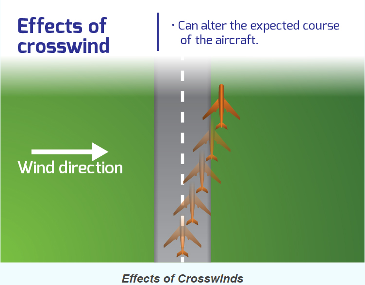


Source: https://www.faa.gov/documentLibrary/media/Advisory_Circular/AC_00-6B.pdf

Note 3-2
In the case of small aircraft, the pilot's ability to operate with crosswind will vary according to the area he has on the aircraft.
During the takeoff run, the influence of the crosswind can cause a small aircraft to drift to the right or left side of the landing runway.
According to the Advisory Circular - AC No. 90-95 of December 1995 issued by the Federal Administration Aviation (FAA) , which deals with Unanticipated Right Yaw in Helicopters, it defined the LTE ( Loss of Tail rotor Effectiveness ) as being a critical situation in which the aircraft is at low airspeed, high power and low altitude, with a left-side or tail-wind component. It is characterized by an inadvertent right turn and, if not corrected in a timely manner, may result in loss of control in flight.
Wind tunnel trials have revealed that winds with velocities between 10 and 30 knots from the left of the aircraft can cause the main rotor vortex, through the action of the relative wind, to interfere with the tail rotor. The effect of this vortex causes the tail rotor to operate in an extremely turbulent environment, which can cause loss of effectiveness, called the loss of efficiency of the tail rotor (LTE), leading to loss of control in flight of the aircraft.

Note 3-3
In helicopters whose rotor rotates counterclockwise, crosswind requires greater availability of engine power, as it generates a clockwise force which is added to the torque resulting from the power applied to the main rotor, also in the direction time, requiring, also greater application of command of pedals, to maintain the directional control of the aircraft.

Note 3-4
When there is a large variation in the intensity of the wind at the time of landing, to the extent that it exceeds the limit set by the aircraft manufacturer, it increases the probability of an inadvertent departure of the aircraft from the runway. For operation at aerodromes that do not have precise direction and wind intensity information, due to absence of a meteorological station or ATS organ, the pilot must be aware of the indications of the bird, to verify if there is possibility of facing a component of tail wind or through

Source: http://www.bom.gov.au # mce_temp_url # /aviation/data/education/wind-shear.pdf
The wind direction indicator is installed at aerodromes in order to be visible to an aircraft in flight, according to item 154.301 (a) of RBAC 154, which establishes the parameters of location, characteristics, dimensions and signaling for the visual indicator wind direction.
Access the RBAC 154 - Amendment 02
At aerodromes that have night operations, at least one wind direction indicator shall be illuminated.

Source: http://www.escoladedrones.com.br/ventos-e-drones-combinacao-perigosa/
Accidents and incidents
The crosswind was mentioned in the investigation reports of the following accidents / incidents
- IG-562 / CENIPA / 2016
- A - 559 / CENIPA / 2015
- A-545 / CENIPA / 2015
- A-008 / CENIPA / 2014
- A-016 / CENIPA / 2012
- A-008 / CENIPA / 2012
- A-129 / CENIPA / 2011
- A-053 / CENIPA / 2010
- A-051 / CENIPA / 2010
CENIPA reports available at http://prevencao.potter.net.br/relatorio/page/1
Wind gusts
When the average wind speed is exceeded by 10 or more knots for at least 20 seconds, it is already considered a gust of wind.
This information is disclosed using the letter G (gusts), followed by the value of the gust, immediately after the average wind speed.
Example:
METAR:
METAR SBMG 281900Z 04010 G 20KT 360V070 9999 FEW010 BKN015 BKN020 22/21 Q1010 =
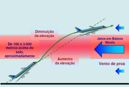
In the figure below, the aircraft takes off and passes through a track with gusting winds. At this stage, it undergoes a sharp increase in lift, propelling it up quickly. When the aircraft leaves the track, in turn, the lift decreases.
As a consequence of the different changes of wind intensity and direction in the vertical wind profile, the characteristics necessary to generate gradients with severe wind shear are created.

Source: https://www.monolitonimbus.com.br/effects-of-vento-about-aircraft/
Burst winds may cause lift loss and change in aircraft trajectory.

Note 3-5
In the case of helicopters, in some accidents involving R-22 / R-44 that were investigated by the NTSB, it was concluded that some situations may lead to contact of the main rotor with the tail cone, among them, the incidence of gusty winds and the large and abrupt movements of the flight controls.
Generally, wind gusts occur up to 3,000 meters above the ground. Above this level, turbulence becomes the most worrying phenomenon.

At high levels, the existence of cirrus or cirrocumulus clouds may indicate occurrence of strong winds at altitude. To minimize possible bumps, it is advisable to slow down the cruise.

Photo: Free Images
To view the cloud type photos, go to the Highlights section of this aeronautical meteorology page.
In the case of operations with small aircraft, gusts of wind may present danger during landing if the blast occurs laterally. In this case, the influence of a lateral gust of wind during the landing may cause a loss of heading (right or left bow), which may result in the aircraft leaving the runway after touching the ground.
In situations like this, it is necessary for the pilot to be attentive to correct the course of the aircraft and to avoid the lateral exit of the runway or overrun (exceedance of the limits of the runway of takeoff and takeoff).

Note 3-6
If the pilot realizes that he will not be able to correct the course of the aircraft, due to the influence of the gust of wind, he can make the decision to carry out a rush procedure.
Gusts of wind also pose a danger to small aircraft that are parked in the airfield yard. In the event of sudden changes in wind direction and speed, these aircraft may suffer structural damage if not properly secured.
In the flight planning phase, the occurrence of wind gusts at the departure aerodrome, along the route and at the destination aerodrome can be identified through the consultation of meteorological bulletins.
Accidents and incidents
This phenomenon was mentioned in the investigation reports of the following accidents / incidents:
- A-516 / CENIPA / 2015
- 125-IG / CENIPA / 2014
- A-081 / CENIPA / 2014
- A-027 / CENIPA / 2012
- A-083 / CENIPA / 2012
- I-036 / CENIPA / 2011
- A-034 / CENIPA / 2011
- A-025 / CENIPA / 2010
CENIPA reports available at http: // prev # mce_temp_url # cao.potter.net.br/relatorio/page/1
- AT75, vicinity Cork Ireland, 2014
- B738, vicinity Eindhoven Netherlands, 2013
- B739, Singapore, 2013
- B738, vicinity Faro Portugal, 2011
- A319, vicinity Wuxi China, 2010
- A320, Hamburg Germany, 2008
- B738, Limoges France, 2008
- B735, Denver USA, 2008
- B732, vicinity Abuja Nigeria, 2006
- A343, Toronto Canada, 2005
- A321, Hakodate Japan, 2002
- B735, near Billund Denmark, 1999
*As notas que contém itens de regulamentos brasileiros não foram traduzidas para que a interpretação delas não seja diferente da interpretação pretendida.
**Notes containing items of Brazilian regulations have not been translated so that their interpretation is not different from the intended interpretation.
Did you find errors in this content ? Send email to meteorologia@anac.gov.br to report.
