Meteorology and Flight Planning
Topics available on this page:
- Sources of meteorological information
- Checklist of operational minima – Meteorology
- Factors that may contribute to inadequate assessment of the meteorological conditions
- How to analyze the risk of rapid weather degradation between takeoff and approach to landing
- General Aviation Pilots Alert
- Accidents and incidents
Sources of meteorological information
The planning of any flight includes, but is not limited to, the detailed study of the meteorological conditions of the place of origin, route, place of destination and alternative location by analyzing the latest weather reports and weather forecasts. Such planning requires adequate anticipation of the take-off time.
Checking the available weather information is a necessary action for a safe flight.
Are you flying in a moment?
Be sure to check the weather information.
 |
|
|
 |
|
|
 |
|
|
 |
|
CGNA Portal - Weather daily briefing. |
Pilots can use Internet resources to increase flight safety.
It is possible to complement the meteorological information provided by the official agencies (DECEA, INMET, CPTEC etc.) using images from live cameras installed at the destination aerodrome. It is one more resource available to aid in the planning of your flight, to avoid adverse weather conditions on the route logo or at the destination aerodrome, increasing flight safety and efficiency.
- FAA Aviation Weather Cameras
- Live Cams in Brazilian Cities
- Live weather conditions at several airports, heliports: http://www.camerasdotempo.com.br/ and http://www.camerasdotempo.com.br/members/members.php
- Radars on the metropolitan region of São Paulo
- Real-time lightning events over South America and the Caribbean
- Weather Stations
- Current conditions of wind, climate and pollution
- Monitoring of the weather conditions in the capital of São Paulo
- Weather forecast
- National Center for Natural Disaster Monitoring and Alerts
- Skyline Webcams
The use of live cameras and information from weather monitoring sites is only efficient if done in conjunction with the meteorological information provided by DECEA - the official aeronautical meteorology service provider in Brazil.
It is not allowed to plan a flight, based solely on images from live cameras and unofficial sites for the preparation of flight documentation. It is mandatory to use the information prepared by the Aeronautics Command, which can be found at: http://www.redemet.aer.mil.br/
CHECKLIST OF MINIMAL OPERATIONAL - METEOROLOGY

Background vector designed by Freepik
Consultation of available meteorological information at take-off, destination, alternate and en-route aerodromes shall be performed according to the sequence of checks below:
|
|
Consult METAR, SPECI, TAF, SIGMET, AIRMET, GAMET and check: Wind conditions, |
|
|
Pay attention to the meteorological minima for VFR and IFR operation established |
|
|
Check that the present wind and the forecast wind fit within the limitations |
|
|
Check logs and weather forecasts for the route to be flown by viewing |
|
|
Check for adverse weather conditions (ice formation, |
|
|
Check conditions for return or precautionary landing in case of |

Access here the Personal Checklist of Operational Minimals - Print version
If you want to print and take the Checklist aboard your aircraft, download the file and at the time of printing, check the options "print on both sides of the paper" and also "towards the small edge".
Mobile version - Access here the Personal Operational Minimal Checklist - Version for mobile phones and smartphones
The Operational Minimums Personal Checklist is an important operational safety management tool. Each item means a different risk factor associated with a flight: pilot, aircraft, environment / aerodromes, and external pressures. This checklist must be used by the pilot during the flight planning phase.
**Notes containing items of Brazilian regulations have not been translated so that their interpretation is not different from the intended interpretation.
Factors that may contribute to inadequate assessment of the meteorological conditions
According to information available in the SIPAER Panel, a data visualization tool developed by the Center for Research and Prevention of Aeronautical Accidents (CENIPA), between 2007 and 2017, 121 occurrences were recorded in Brazil in which adverse weather conditions acted as possible contributing factors . In 38 of these events, CENIPA researchers concluded that there was an inadequate assessment of the meteorological information available during flight planning.
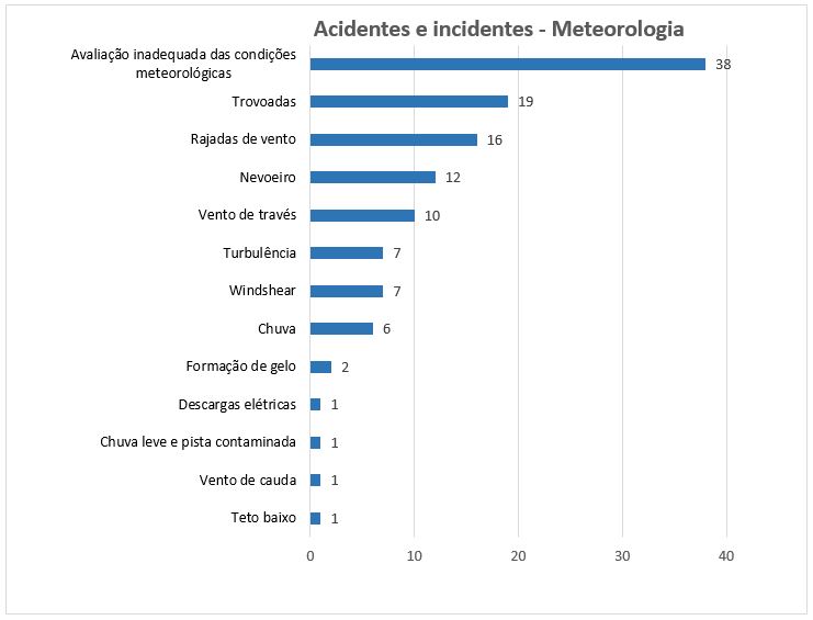
Graph based on information extracted from the SIPAER Panel on 05/10/2018 (CENIPA: http://www2.fab.mil.br/cenipa/)
The investigation reports of these occurrences pointed out the factors that may have contributed to an erroneous evaluation of the meteorological conditions, among which the following stand out:
• Self confidence: flight planning was carried out without considering available meteorological information or considering only isolated meteorological information, without taking into account all the information;
• Unavailability of meteorological information: There was difficulty access to meteorological information, lack of available means (internet, telephone) or lack of local meteorological information (METAR and TAF);
• Interpretation error: There was a query to all available meteorological information, but the crew was not able to interpret the information properly.
• External pressures: After assessing meteorological information, conditions imposed by the owner of the aircraft, by passengers or by the crew themselves were taken into account in the decision-making process. Important commitments such as marriages, meetings, family gatherings and other pressures outside the operating environment have influenced the crew's perception of weather risk management.
Note 9-20
It is recommended that pilots know and respect their own operational limitations. During flight planning, when evaluating the available weather information, external pressures from the operating environment, such as conditions imposed by the owner of the aircraft or passengers, and the thoughts "we must arrive at our destination" or "let's go home" influence the decision-making process of weather risk management.
External pressures, self confidence, unavailability of meteorological information and errors of interpretation should be avoided during the assessment of meteorological conditions.
How to analyze the risk of rapid weather degradation between takeoff and approach to landing
During the planning of the operation, an important aspect to be considered is the possibility of rapid degradation of the meteorological conditions that can occur in the time between takeoff and approach to landing.
Adverse meteorological phenomena can cause a sudden reduction of visibility, a condition favorable to spatial disorientation, a condition in which the accelerations imposed on the pilot due to the movement of the aircraft influence his perceptive references, leading him to believe that he is flying under certain conditions (level, inclined, for example) when, in reality, the aircraft may be in totally different conditions from those perceived.
In order not to be surprised by a rapid degradation of the meteorological conditions between takeoff and landing approach, it is necessary to check the meteorological bulletins, considering the following recommendations:
- When available, check the Aerodrome Forecasts Terminal - TAF and Meteorological Terminal Report - METAR for destination and alternate aerodromes. If such information is not available, meteorological messages should be sought from nearby aerodromes as they will be a useful source of information to aid in decision making;
- Have prior knowledge of the visibility conditions at the departure aerodrome, along the route and at the destination aerodrome;
- Check that there is a forecast for meeting the cold front or Cumulunimbus cloud or if there are other adverse weather conditions that may reduce visibility during the planned flight;
- Ensure the probable height of the base and top of the clouds to be found along the route. According to the current ceiling and visibility limits, it is possible to identify the margin between the cloud bases in the meteorological and terrain information along the route and whether there is a need to change the level of flight. This analysis allows to know if the terrain will be a risk factor, in case it is necessary to fly lower to stay out of the clouds;
General Aviation Pilots Alert
Standard check lists are even more important in and around severe weather. Be aware of weather conditions throughout the entire route of your planned flight. A pilot’s failure to recognize deteriorating weather conditions continues to cause or contribute to accidents.
Source: Federal Aviation Administration – FAA
Accidents and incidents:
The assessment of meteorological information available during flight planning was mentioned in the investigation reports of the following accidents / incidents:
|
A-520 / CENIPA / 2016 |
A-004 / CENIPA / 2014 |
A-092 / CENIPA / 2012 |
A-056 / CENIPA / 2010 |
|
A-519 / CENIPA / 2016 |
A-593 / CENIPA / 2014 |
A-077 / CENIPA / 2012 |
A-082 / CENIPA / 2010 |
|
A-055 / CENIPA / 2015 |
A-048 / CENIPA / 2014 |
A-027 / CENIPA / 2012 |
A-053 / CENIPA / 2010 |
|
A-545 / CENIPA / 2015 |
A-011 / CENIPA / 2014 |
A-041 / CENIPA / 2012 |
A-051 / CENIPA / 2010 |
|
A-507 / CENIPA / 2015 |
A-113 / CENIPA / 2013 |
A-129 / CENIPA / 2011 |
A-048 / CENIPA / 2009 |
|
A-543 / CENIPA / 2015 |
A-052 / CENIPA / 2013 |
A-090 / CENIPA / 2011 |
A-42 / CENIPA / 2009 |
|
A-523 / CENIPA / 2015 |
A-098 / CENIPA / 2013 |
A-034 / CENIPA / 2011 |
A-041 / CENIPA / 2009 |
|
A-560 / CENIPA / 2014 |
A-040 / CENIPA / 2013 |
A-011 / CENIPA / 2011 |
A-024 / CENIPA / 2009 |
|
A-043 / CENIPA / 2014 |
A-029 / CENIPA / 2013 |
A-051 / CENIPA / 2011 |
A-005 / CENIPA / 2007 |
|
A-116 / CENIPA / 2014 |
A-024 / CENIPA / 2013 |
A-001 / CENIPA / 2011 |
|
|
IG-111 / CENIPA / 2014 |
A-060 / CENIPA / 2013 |
A-091 / CENIPA / 2010 |
|
|
A-052 / CENIPA / 2014 |
A-169 / CENIPA / 2013 |
A-017 / CENIPA / 2010 |
Reports available at http://prevencao.potter.net.br/relatorio/page/1
About the weather conditions that affect aviation, visit: https://www.anac.gov.br/en/safety/aeronautical-meteorology